Strategic Planning and Implementation of Agri-Environment Schemes
Project Status: Completed (See Final
Report Summary)
Type of Project: Scoping Study
Principal Investigator: Dr David MacDonald, Oxford University
(Email)
Website
Publications, Data and Other Outputs
Objectives
Payments to farmers are shifting from production-based subsidies towards grants for conservation work, such as habitat enhancements. The benefits and costs of this work vary greatly from farm to farm, and understanding the benefits is further complicated by the fact that they depend partly on the conservation work conducted on surrounding farms. This project aims to unravel these complications in order to calculate the net benefits of a project at the landscape level, and so derive the most efficient way to employ resources for conservation.
Why is this project important?
Intensification of farming over the last fifty years has fragmented
the natural habitats of many native species. This fragmentation leaves
small populations vulnerable to extirpation following shocks, where
previously they would be replenished through immigration from surrounding
populations. If conservationists are to protect these species they need
to increase habitat connectivity between populations on a landscape
level. In order to do this it is important that they understand the
most efficient way in which to use the limited resources available.
What are we doing?
Initially, we are gathering information on the costs to individual
farms of becoming involved with environmental projects, and also the
likelihood of their becoming involved, given varying incentives. In
terms of the benefits, we are collecting information on the values that
local people attach to particular changes to their surroundings, and
to the protection of biodiversity in their local area. These cost and
benefit data will be combined with a biological model of the response
of water vole populations to habitat enhancement work. The predicted
changes to the vole populations will be converted into a monetary value
using existing studies.
This information will be combined using a Geographical Information System.
This GIS will then be set to derive the most efficient employment of
habitat enhancement work given current grant incentives and 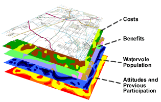 the
aims and specifications of a particular conservation programme.
the
aims and specifications of a particular conservation programme.
Layers of data involved in producing the GIS
By January:
We will have data from farms in two case study areas covering:
• What they farm and where, in order to produce an opportunity
cost for pulling land out of production.
• Their past participation in agri-environmental work.
• Their attitudes and opinions from a set of questions already
linked to certain actions from previous studies.
• Whether or not they would be willing to participate within the
UTTESA project
• The amount they would need to be paid in order to carry out
specific agri-environmental work on different fields
• And various demographic data
The final 5 areas are there to model what these farmers
are likely to do on their farm given various incentives. These questions
will also have been sent to a set of farmers, which have already been
involved in a similar environmental project. This will provide an extra
sample based on revealed preferences as opposed to contingent ones.
We will also have data from local groups covering:
• How often and what they use their local area for
• How they would value agri-environmental work being carried out
in areas they use, dependant on the regularity of use. This will be
in terms of both time and money.
• There will also be demographic data
On the data front we will also have a more straightforward valuation of the project from local people, simply valuing the project as a whole. This data-set will also test the effect of education on the valuation. Half will be given information explaining why fragmentation of habitats makes this work important. The other half will not be told why, they will only know what the project consists of in terms of its work and how it might effect them, and that it aims to protect biodiversity. Both sets will have this information.
Come January we should be well on the way analysing this data and building the GIS to fit it all into. The information on the new Entry Level stewardship will hopefully be available and we can begin to use the information we have to work out what work each farm might be willing to do were the compensation based on this scheme.